Project Description
Click to enlarge.
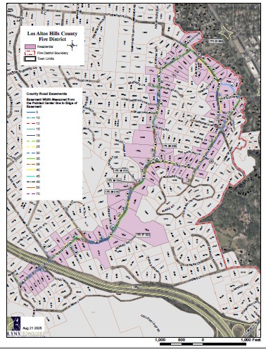
Portions of Robleda-Burke evacuation route maintenance project represent a significant thoroughfare for the central Los Altos Hills Community. These roads serve as egress and ingress for local residents, daily commuters, and emergency services. To secure the egress / ingress’ integrity, the Los Altos Hills County Fire District proposes a roadside treatment of fuels.
Project Site
The Robleda-Burke project will treat six (6) roads along the evacuation route. These include Robleda Road, Chapin Road, Fremont Road, W. Edith Avenue, Burke Road, and Old Altos Road.
This project will treat the following sections of each road:
- Robleda Road: From the intersection of Elena Road (37.364907, -122.137449) to the intersection of Fremont Road (37.380174, -122.124167). Approx. 1.5 linear miles, 3.0 treated miles.
- Chapin Road: From the intersection of Robleda Road (37.372233, -122.127559) to the intersection of Burke Road (37.372521, -122.123477). Approx. 0.3 linear miles, 0.6 treated miles.
- Fremont Road: From the intersection of W. Edith Avenue (37.380451, -122.124609) to the intersection of Burke Road (37.375249, -122.121435). Approx. 0.43 linear miles, 0.86 treated miles.
- W. Edith Avenue: From the intersection of Fremont Road (37.380451, -122.124609) to the intersection of University Avenue (37.381296, -122.121895). Approx. 0.16 linear miles, 0.32 treated miles.
- Burke Road: From the intersection of Chapin Road (37.372521, -122.123477) to the intersection of University Avenue (37.377275, -122.118805). Approx. 0.44 linear miles, 0.88 treated miles.
- Old Altos Road: From the intersection of Burke Road (37.377095, -122.120003) to the intersection of Fremont Road (37.377128, -122.121805). Approx. 0.10 linear miles, 0.20 treated miles.
Total Treated Miles: 5.86
Schedule
The project is scheduled to start November 4, 2025.